
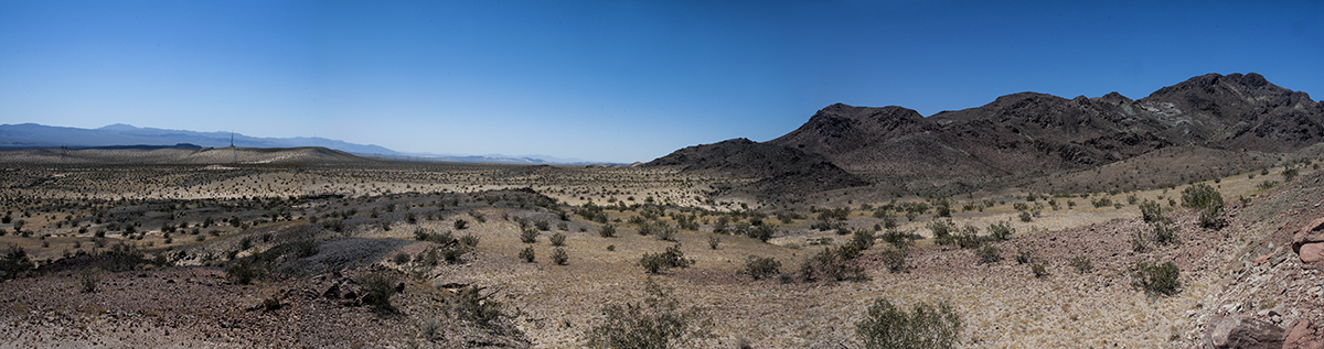
View of the Mojave Valley floor from the vicinity of the Sleeping Beauty collecting area in the South Cadys, May 2017. Photo: Lisbet Thoresen.
BLM's land use and route network plans
provide a solid foundation for drafting
a monument plan for Mojave Trails
February 9, 2024
by Gregor Losson

BLM Sacramento environmental specialist Mike Sintetos, lifelong rockhound Bill Depue, Mojave Trails monument manager Kyle Sullivan, and rockhound Joe Sumners with the train trestle near the Afton Canyon campground in the background during the superbloom of 2019. Photo: Lisbet Thoresen.
The designation of the Mojave Trails National Monument (MTNM) by presidential proclamation on February 12, 2016 was not the beginning of the fight to preserve our historic hobby in the Mojave Desert of Southern California. It was the beginning of an eventual determination on the management of its 1.67 million-acre footprint, which is expected to be made final by the summer of 2024. Long before the monument was created, a sweeping land use plan amendment known as "DRECP" and a detailed route network plan known as "WEMO" were in the works. They were not finalized until after the monument designation for Mojave Trails, but the Bureau of Land Management (BLM) has always been acutely aware that down the road these planning products would have to be incorporated into the final monument management plan for Mojave Trails.
There is a long history and voluminous paper trail attesting to BLM's promised accommodations of hobby collecting (or "rockhounding") as a permissible recreational activity in the monument. Collecting areas and routes to them have been identified and negotiated thoughtfully and in great detail over a period of 18 years. We do well to remind ourselves and BLM that a final monument management plan for Mojave Trails has its roots in painstakingly cultivated ground.
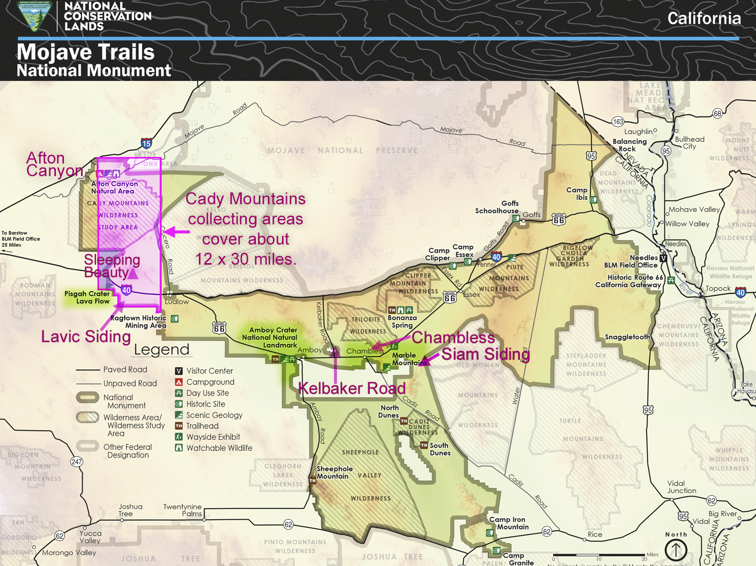
Mojave Trails National Monument with some of the historically most important collecting areas labeled among many located throughout the monument: they include Afton Canyon, the Cady Mountains (a broad area covering 12 x 30 miles highlighted in pink), Lavic Siding, Kelbaker Road, Chambless, the Marble Mountains, and Siam Siding. Source: BLM. Annotations: B. Depue and L. Thoresen.
Background: Desert Renewable Energy Conservation Plan (DRECP)
In 1994 the Trilobite, Bigelow Cholla, Piute Mountains, Cadiz Dunes, and the massive Sheephole Valley were established. It resulted in the elimination of roads covering a combined 341,980 acres, which later became part of MTNM. The Desert Renewable Energy Conservation Plan (DRECP) was a Land Use Planning Amendment (LUPA) – essentially a zoning plan – for the entire California desert. It is the most ambitious LUPA in California state history. It was more than eight years in the making. It gave conservation designations to most of the desert when the Record of Decision (ROD) was adopted in September 2016. This accounts for the various Areas of Critical Environmental Concerns (ACECs) that currently cover much of MTNM. Rockhounds contributed numerous detailed comments during the drafting period, and the final plan formally gave rockhounds every single concession they asked for: every hobby collecting site and route was accommodated in the ROD of DRECP, some carved out from areas designated for energy development.
Background: West Mojave Plan (WEMO) / West Mojave Route Network Plan (WMRNP)
The West Mojave Plan (WEMO) is the direct planning process that produced the Route Network Plan for the western part of Mojave Trails. Its scope covers the entire Cady Mountains, from the historic Baxter Wash collecting areas in the north to the historic Sleeping Beauty collecting areas in the south. Hundreds of hobby collecting areas and historical mines with legally designated routes of access to them are found in the Cadys. They are distributed over a broad area covering about 12 × 30 miles.
WEMO is the Travel Management Plan for the western Mojave Desert. It became known as the West Mojave Route Network Plan (WMRNP). Rockhounds were among the hundreds of volunteers who spent thousands of hours on the ground collecting GPS coordinates on collecting areas and routes of access to them, which they provided to BLM. The Record of Decision was published in 2019, taking 13 years to complete. The planning for WEMO originated in the WEMO Subgroup of the Desert Advisory Council of (DAC), which represents public interests and reports directly to BLM. The subgroup created a map of all existing roads in the west Mojave and implemented a process for evaluating each road and reducing the total miles within the map to comply with the plan.
“Rockhounding in the California Desert District has been a family activity and hobby for generations of Californians. The BLM is committed to focusing on rockhounding, and other recreational activities, in the development of the management plan for Mojave Trails National Monument. Input from the rockhounding community will be essential in helping us identify appropriate management actions that balance access with resource protection.”
— Kyle Sullivan
BLM manager (2016–2020),
Mojave Trails National Monument
WEMO was established to close roads
So, which roads to close? Rockhounds stepped into the fight over route closures on day one – in 2006. BLM personnel changed over the years, which required us to educate new arrivals to the desert about the customs and culture of the land and its rockhounding history dating back to the 19th century. BLM's proposed draft plans would be adjusted to reflect public input obtained from comment periods mandated by the National Environment Policy Act (NEPA). Each iteration of a draft plan triggered an opportunity for public comment per NEPA. The plan survived an environmentalist lawsuit but had to be adjusted, which required still more comment periods and years of delays in drafting a final plan. Many individual rockhounds, gem-mineral societies, the California Federation of Mineralogical Societies (CFMS), and the American Lands Access Association (ALAA) fought continuously for 13 years to protect the interests of rockhounds.
2016 was a watershed year
While WEMO was still ongoing, Mojave Trails was designated a national monument in February 2016 and a Record of Decison for DRECP was published seven months later, in September. The dilemma for BLM was at hand: how to fit the three plans together? The BLM decided to finish DRECP first because each area of that plan had “Disturbance Caps,” which set limits on the percentage of land in each area that could be disturbed by roads, mines, utilities, or other human-related activity. By design, the WEMO Route Network Plan would be completed after DRECP, so, if necessary, the road networks could be downsized to comply with DRECP’s Disturbance Caps. When WEMO/WMRNP was finalized in October of 2019, rockhounds had saved access to some of our most significant historic collecting area. However, many were lost in the process.
By design, WEMO/WMRNP is the blueprint for Mojave Trails
From the beginning of the planning process for drafting a monument management plan for Mojave Trails, WEMO/WMRNP was meant to be the authoritative reference for the road network in the monument where overlaps existed, specifically, in the Cady Mountains, from the north to Sleeping Beauty in the south. Since 2006, the rockhound community has participated in every step that shaped WEMO/WMRNP. We expect BLM to adhere to this plan and keep open the currently designated WMRNP roads in the Cady Mountains. Over the years, the monument managers have consistently reaffirmed this commitment. WEMO/WMRNP’s overlaps in the monument are only a small part of Mojave Trails. Two other route plans currently cover the majority of the monument, and they will probably be the subject of travel planning processes far into the future.
Cite this article: G. Losson. 9 February 2024. BLM's land use and route network plans provide a solid foundation for drafting a monument plan for Mojave Trails. San Diego Mineral & Gem Society. Available online at: https://www.sdmg.org/articles/202402/mojave-trails-monument-management-plan/.
Read SDMG's comment letter to the BLM on its management plan for Mojave Trails».
Sign up to SDMG's mailing list to receive updates on Mojave Trails (check all the boxes that apply to your interests; don't forget, you will receive a verification email from Constant Contact containing a link to activate your enrollment). Questions on this topic can be directed to editor@sdmg.org.