
BLM RESOURCES FOR ROCKHOUNDS

BLM's proposed review of DRECP
Special DAC meeting
March 20, 2018, noon to 5pm
Hilton Garden Inn, Mirage Room, 12603 Mariposa Rd.
Victorville, CA 92395
Come to the meeting and tell BLM to leave the DRECP alone.
Download the BLM press release for details »
BLM's Desert District Advisory Council (DAC) will hold its first meeting in over one year. The DRECP Review prompted the special meeting. There is no upside for Rockhounds, if BLM opens DRECP to review, but there is risk of downside. Download a Fact Sheet on What Rockhounds got in DRECP, misconceptions about what DRECP did not do, and what the unintended consequences could be for Rockhounds, if BLM goes forward with amending the DRECP to make more opportunities for renewable energy projects in the desert. Read more »
Comment Period Deadline: March 22, 2018
Rockhounds, get your name on a letter…
BLM opened a 45-day comment period on February 2nd. Rockhounds have until March 22nd to submit letters.
Read an article on why amending DRECP is unnecessary and could be bad for Rockhounds ».
Download a FAQs sheet on the DRECP »
To ensure continued access to hobby collecting areas in California's deserts, BLM needs to hear from Rockhound advocates. SDMG has prepared a detailed comment letter. If you or your club would like to sign onto our letter:
● Download the current draft version of SDMG's letter at: https://goo.gl/kNbkiM (short URL).
● Download a flyer on how to sign onto SDMG's letter (2 easy steps) »
Want to write your own letter? Download a flyer with FAQs and useful comments on DRECP »
Writing a Good Comment Letter
What's Effective, What's Not
Download a flyer:
https://www.sdmg.org/blmdocs/comment_letters_whats_effective_whats_not.pdf
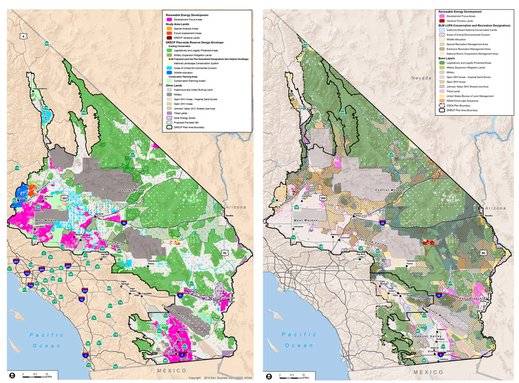
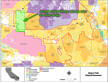
Left: DRECP Preferred Alternative Plan in February 2015 showing Development Focus Areas (DFAs)(magenta-colored areas), targeted for utility-scale renewable energy projects. Right: Final DRECP as of Sept 14, 2016 showing changes to DFAs, some of which were made accommodate Rockhounds based on comment letters. The 2018 DRECP Review could take away concessions made to Rockhounds.
If you or your club would like to sign a joint letter to support hobby collecting, contact editor@sdmg.org for more information.
DRECP do-over may give lands designated for
recreational uses to industrial-scale projects
by Lisbet Thoresen
Public Lands Representative
for San Diego Mineral & Gem Society
February 2, 2017
BLM notice of intent (2/2/2018): Docket Number 2018-02098
What it proposes: Amend DRECP to seek greater opportunities for renewable energy generation.
Where to find it: https://www.federalregister.gov/d/2018-02098
Comment period deadline: 3/19/2018
After a bruising 8-year battle and 16,000+ comment letters later, the Desert Renewable Energy Conservation Plan (DRECP) is in full implemention and on pace to fast-track permits for 500 renewable energy projects over the next 10 years. Apparently, that's not enough for Industry advocates. After less than 18 months, BLM will consider rewriting DRECP to give Industry lands set aside for conservation and recreation, including hobby collecting. Some of these lands were originally designated for development in the Draft DRECP, but after receiving numerous detailed comment letters from Rockhounds, they were re-designated to accommodate hobby collecting in the DRECP Record of Decision published on September 14, 2016.
BLM opened a 45-day comment period on February 2, 2018. To ensure that access to collecting areas is not lost to industrial projects Rockhounds must reiterate anew their concerns to BLM by the comment period deadline on March 19, 2018.
Read more about DRECP and why it matters to Rockhounds »
Left: Draft (preferred alternative) DRECP showing Development Focus Areas (DFAs)(magenta-colored areas), where utility-scale renewable energy projects could be built. Right: Final DRECP showing removal of DFAs, some of which were changed to accommodate Rockhounds based on comment letters.
A blueprint for comment letters
by Lisbet Thoresen
Public Lands Representative
for San Diego Mineral & Gem Society
November 1, 2016
Everyone who has ever written a comment letter knows what a labor-intensive, time-consuming exercise it is to gather all the information required to get collecting sites written into a Management Plan. We feel your pain.
In a joint effort, SDMG and CFMS prepared a comment letter on the Management Plan for the San Gabriel Mountains National Monument (SGMNM). Other clubs, non-profit organizations, and academic-affiliated and professional individuals were invited to be signatories. The SGMNM comment letter was submitted to the U.S. Forest Service on October 17th. Thank you to everyone who signed onto the letter:
- American Federation of Mineralogical Societies
- Diamond Pacific Tool Corporation
- North Orange County Gem & Mineral Society
- Oxnard Gem & Mineral Society
- Palomar Gem & Mineral Club
- Rocky Mountain Federation of Mineralogical Societies
- Stewards of the Sequoia
The SGMNM letter will be our template for submitting comment letters going forward. We will need signatories – but a whole lot more of them.
Rockhounds, help us help you.
We would like every gem-mineral club in California and more AFMS affiliates, as well as Stakeholder organizations nationwide to sign onto our comment letters. We will still need your input on collecting area information – we cannot know everything – but we'll do most of the heavy lifting to write a good letter.
Our next big effort has already started on the Management Plan for the Mojave Trails National Monument (MTNM). To learn more about what's in store, read Lisbet Thoresen's report on the Desert District Advisory Council (DAC) meeting held in Riverside in October 2016 (the report also appears in SDMG's November 2016 bulletin).
The future of Rockhounding in the Cady Mountains, Lavic Siding, Afton Canyon, and many other favorite collecting areas within MTNM's footprint is going to be decided with or without your input. So, let's pull together. Contact Lisbet Thoresen at info@sdmg.org, if you have questions, input, or you want to ask her to make a presentation to your club.
(Download a print-friendly PDF of the "Blueprint for comment letters" article, which appears in SDMG's November 2016 bulletin.)
DAC meeting report:
Progress and process on managing desert public lands
by Lisbet Thoresen
Public Lands Representative
for San Diego Mineral & Gem Society
October 31, 2016
The DAC business meeting held in Riverside on October 15th was a full day of good presentations and productive discussion focused mostly on Phase II (implementation) of the Desert Renewable Energy Conservation Plan (DRECP) and the Management Plan process for the Mojave Trails National Monument (MTNM). Among the topics of particular interest to Rockhounds was a presentation on DRECP by Russell Scofield, BLM Natural Resource Specialist. He is new to Southern California, and perhaps more than any other single person, Mr. Scofield may decide what accommodation of Rockhounding will be made in Southern California's desert in the future.
Mr. Scofield has been tasked with overseeing implementation of DRECP with the local counties. He is currently working on the First 100 Days Plan – the start date was the signing of the Record of Decision on September 14, 2016. The First 100 Days Plan is a schedule of actionable items, then priorities, budget, and scoping. He wants to reach out to special interest groups (Stakeholders) as part of his commitment to public engagement.
Other important topics were covered at the DAC business meeting. The Management Plan process for Mojave Trails National Monument (MTNM) was outlined by Mike Ahrens, BLM Field Officer, Needles. BLM appears intent on creating a final Plan for the monument within the three-year time limit allowed by law. MTNM is the second largest monument in the system. Given its size and the number of collecting areas within its footprint, Rockhounds have a lot of work ahead of them to identify the collecting areas that need to go into the Plan. (SDMG and CFMS are working on a comment letter that other organizations can sign onto. Stay tuned for more about this joint effort in the weeks ahead.)
Another meeting topic was the bureaucratic morass of Land Use Plan Amendments (LUPAs) and the processes guiding them, which are becoming increasingly complicated. Overlaps and conflicting directives exist in multiple plans, including DRECP, WMRNP and potentially, Planning 2.0 initiative. The issue of conflicts was visited several times throughout the day-long DAC meeting, because it touched on almost every topic and planning effort under discussion.
We will be hearing a lot about Disturbance Caps (DCs) in the future. DCs are a measure of the intrusion or harm imposed by human activity on the environment. BLM FO Katrina Symons (Barstow) is currently preparing a Disturbance baseline study, which will be released in May-June, 2017. DCs will be calculated for all the different activities in the desert, including Rockhounding. DCs accrue cumulatively against the activity overall; they are not segregated and measured as locality-specific impacts. Rockhounds stand to lose a lot, if our DCs are lumped together with commercial mining. Also, high disturbance measured at a single collecting area can skew the overall scoring or cap. The criteria for scoring DCs could adversely impact access to any collecting area, even if it individually scores "low," because the score will be averaged across all areas and applied to all of them. Read the entire DAC mtg report »
(Download a print-friendly PDF of the October 2016 DAC meeting report.)

Public Lands Policy Milestones
October 4, 2016
Three major Public Lands Policy milestones have significant near- and long-term implications for Rockhounding in Southern California:
- the Desert Renewable Energy Conservation Plan (DRECP)
- Mojave Trails National Monument
- San Gabriel Mountains National Monument
A presentation made by Lisbet Thoresen at the SDMG General Meeting in September discusses these watershed milestones in the context of land use policy developments and what they portend for the next 25 years. The presentation also addresses what Rockhounds need to understand about the National Monument Management Plan drafting process and how to participate in it, so that it works for them. (Download a print-friendly PDF of the presentation slide deck.)
Read the Public Lands update »
Attend one of
the Envisioning Sessions
5:00–7:30pm
at all three venues
Barstow · Tue, Aug 30, 2016
Location: Hampton Inn
2710 Lenwood Road
Barstow, CA, 92311
Yucca Valley · Wed, Aug 31, 2016
Location: Yucca Valley Community Center
57090 Twentynine Palms Hwy
Yucca Valley, CA, 92284
Needles · Thu, Sept 1, 2016
Location: El Garces Hotel
950 Front Street
Needles, CA, 92363
For more information contact:
Stephen Razo
BLM California Desert District External Affairs
951-697-5217 or srazo@blm.gov
View the "Envisioning Sessions" flyer »
Here we go Rockhounds –
the planning process for
Mojave Trails National Monument
(MTNM)
is about to begin
by Ruth Hidalgo, ALAA
May 18, 2016
ALL THE COLLECTING AREAS within the Cady Mountains, most of the Lavic collecting areas and all the spots along the Route 66 corridor are now within the MTNM. If Rockhounds are going to have any chance at all of being able to continue collecting within the new National Monument, we are going to have to PARTICIPATE IN THE MANAGEMENT PLANNING PROCESS. The Management Plan for this Monument will be undertaken under a new Planning Process called Planning 2.0. As part of that process, the BLM is hosting "Envisioning Sessions."
This is your chance to let BLM know that Rockhounds ENVISION being able to continue collecting rocks as we have done for over 70 years on the lands now within the monument; that we ENVISION the roads and trails we use to reach our known collecting areas should remain open in the Travel Management Plan; that we ENVISION a net zero loss of trails that provide access to the collecting areas we use; that we ENVISION unlocked gates, staging areas and parking areas for club outings, as well as other amenities that would enhance recreational experiences in the MTNM.
Participating is not hard or complicated. Just show up and speak up. This is a scoping session, and it would be great if Recreational Rockhounding was at the top of the list of the input BLM receives.
There are three meetings scheduled at the end of August and first day of September. All sessions will be from 5:00 to 7:30 pm. See venue addresses in the box at right. View the "Envisioning Sessions" flyer for more info.
Let's be effective
In the months ahead, look for updates and calls to action here, on the SDMG website under "BLM Resources." When the comment period opens on the management plan for the Mojave Trails National Monument (MTNM) – and it will be a tiny window if BLM is true to pattern – Rockhounds will need to be ready to submit detailed letters with exhibits (we'll dive into this issue in the coming weeks and months ). You can start crafting your letter now – but WAIT to submit it to BLM. If you use Twitter, use the hashtag #CalNatMonuments (to be effective, be respectful, not frothy).
Rockhounds will be heard only if we speak in a coherent, unified voice. That means forging alliances with groups or legislators who have not been sympathetic to Rockhounds in the past. There's a bigger adversary now, and they see it. Rockhounds would do well to recognize the sea change, as well.
If and when you write any letter or email, or you have resources to share about maps, routes, collecting areas, please be sure to send a copy via e-mail or s-mail to the contact addresses below – that way, the efforts of Rockhounds in aggregate can be tracked.
- e-mail: calnatmonuments@amlands.org
- s-mail: ALAA
2010 West Ave. K #528
Lancaster, CA 93536-5229
BLM Field Tour: Lavic Siding
May 20, 2016
DAC Business Meeting: Barstow
May 21, 2016
June 1, 2016
Read the whole riveting report »
IT'S OFFICIAL. Rockhounds may continue to collect – temporarily – at their favorite sites located within the newly created Mojave Trails National Monument (MTNM) while a Management Plan for the monument is being drafted. BLM Field Manager Katrina Symons organized a day-long tour of sites near Barstow that are located within the monument. The objective was to familiarize the public and the eleven members of Desert District Advisory Council (DAC) with the monument – its unique geological and ecological features, as well as the customs and culture of the land, from grazing to recreational activities such as rockhounding and off-roading. She invited former DAC member Kim Campbell Erb to make a presentation for the rockhounding segment of the tour, which was held at the main collecting site at Lavic Siding. Kim did a fabulous job of explaining the values of Rockhounds and the significance of the collecting areas within the MTNM. As a Rockhound and former DAC member, she was the perfect messenger.
Kim got a great deal of support from a lot of Rockhounds who showed up at Lavic carrying placards and bringing rocks and pictures to share with the visitors. Members from several clubs turned out in impressive numbers, including Antelope Valley Gem & Mineral Club, Culver City Gem & Mineral Society, North Orange County Gem & Mineral Society, Orange Belt Mineralogical Society, Sierra Pelona Rock Club, and Mojave Desert Gem & Mineral Society. Kris Rowe led a group of Rockhound Fanatics on a Lavic Rockhound Round-Up. The BLM field managers and DAC members were pretty impressed by the turn-out and what they learned about Rockhounding. Thanks to one and all who showed up. A big shout-out to Katrina Symons, who gave Rockhounds a soapbox.
The warm fuzzy feelings continued right on through the DAC business meeting, which was held the next day in Barstow. Rockhounding was not an agenda item, but Rockhounds got two chances to have comments entered into the record. More Rockhounds spoke at the meeting than any other group represented. A comment letter on the MTNM Management Plan from SDMG was entered into record.
Read SDMG's comment letter on the MTNM; also at: http://goo.gl/t7urKB (short url). Heaps of thanks to Bill Depue and John J. Pickett of Diamond Pacific Tool Corporation for providing geographic references and pictures for the letter. Thanks also to Tim and Diane Brady George for lending their lovely pictures for the exhibit appended to the letter.
DAC Field Tour
Route 66 and Mojave Trails National Monument
Friday, May 20, 2016 8:00am – 5:00pm
Join an all-day tour of BLM public lands within the newly designated Mojave Trails National Monument. Various topics will be highlighted for discussion at the different stops. Kim Campbell Erb will talk to rockhounds at Lavic from 2:00pm to 2:45pm.
The public is welcome, but you are responsible for providing your own transportation, food, and beverages. Departure from Hampton Inn parking lot in Barstow.
Details and itinerary to be published at:
http://goo.gl/5vr3hW (BLM short url)
Contact: Stephen Razo, BLM California Desert District External Affairs
951-697-5217 or srazo@blm.gov
Participate in the DAC Meeting
on Saturday, May 21, 2016
DAC will convene a formal all-day meeting on May 21st in Barstow (see details in the box below). DAC will consider creating a Mojave Trails National Monument subgroup, which will assist and advise BLM on what will go into the Final Management Plan for Mojave Trails. Folks, this is our chance to ensure that rockhound interests are addressed from the start.
Write a letter TODAY
Find out where to send your letters »
Click here to download a sample letter.
(Look for it in your downloads folder;
it will not open in a browser window.)
Attend the California Desert
District Advisory Council (DAC)
meeting in Barstow
Sat, May 21, 2016 8:00am – 5:00pm
Location: Hampton Inn
2710 Lenwood Road
Barstow, CA, 92311
Jackrabbit 2 Meeting Room
Be sure to double check
the meeting location
shortly before the meeting date.
http://goo.gl/5vr3hW (short url)
Agenda for the Saturday meeting will include updates by council members, the BLM California Desert District Manager, five Field Managers, and council subgroups. Focus topics for the meeting will include Route 66 Corridor Management Plan and renewable energy project updates.
Submit written comments
prior to the meeting
- Bureau of Land Management
External Affairs
22835 Calle San Juan de Los Lagos
Moreno Valley, CA 92553 - Written comments also are accepted at the time of the meeting and, if copies are provided to the recorder, will be incorporated into the minutes.
Click here to download a sample letter. (Look for it in your downloads folder; it will not open in a browser window.)(Look for it in your downloads folder; it will not open in a browser window.)
The 15-member council advises the Secretary of the Interior, through the BLM, on a variety of planning and management issues associated with public land management on BLM administered lands in the California desert. Public comment for items not on the agenda will be scheduled at the beginning of the meeting on Saturday morning.
Time for public comment is made available by the council chair during the presentation of various agenda items, and is scheduled at the end of the meeting for topics not on the agenda.
Members of the public interested in a particular agenda item or discussion should schedule their arrival accordingly.
For more information contact:
Stephen Razo
BLM California Desert District External Affairs
951-697-5217 or srazo@blm.gov
https://federalregister.gov/a/2016-09941
Mojave Trails National Monument:
Rockhounds get some
rock solid support
by Lisbet Thoresen
May 18, 2016
MOJAVE TRAILS is the largest of three national monuments created in California's deserts in February. It covers 1.6 million acres and many collecting areas popular with rockhounds. Because the Proclamation did not specifically include rockhounding as a permissible activity within the new national monument, it left many members of the rockhound community wondering how the BLM was going to interpret the Proclamation while a Management Plan was being drafted. A Management Plan is supposed to be published within three years, which is a long time for rockhounds to linger in limbo.
The BLM's position since February had been vague, intimating, when asked, that it hoped to implement an interim policy favorable to rockhounds. In the meantime, several Gem & Mineral clubs and the California Federation of Mineralogical Societies (CFMS) suspended sponsorship or participation in field trips to the National Monuments until there was a clear policy. It was not apparent as recently as one week ago that there would be guidance forthcoming any time soon.
Fortunately, the plight of rockhounds caught the attention of Los Angeles Times writer Louis Sahagun. His May 7th article, "A lost gem? New Mojave Trails monument rules appear to bar rock hunting" elevated the dilemma to the awareness of the general public. The reverberation for rockhounds – or perhaps, symmetry in the universe – was swift and positive.
On May 12th, SDMG received a copy of a letter Senator Dianne Feinstein (CA-D) sent to Secretary of the Interior Sally Jewell. The Senator asked for clarification about rockhounding during the interim period while a Management Plan is being drafted. Her letter went a lot further. It described the values and activities of rock collecting hobbyists in a genuinely positive light, noting that rockhounding has long been regarded and managed by BLM as a permissible recreational activity on public lands. She advocated for the policy to continue, whether under oversight of the BLM, U.S. Forest Service, or the National Park Service. She asked for inclusion of clear language to that effect in the Management Plans for the three new National Monuments, which were created because of her advocacy dating back two decades.
The next day, on May 13th, California State BLM Director Jerome Perez made it official, publishing on the BLM website that rockhounding is a permissible activity in the Mojave Trails National Monument. It says:
The Presidential proclamation that designated the Monument provides latitude for existing uses and activities and does not limit or prohibit rock hunting. Rockhounders are welcome to continue collecting limited amounts of rocks, minerals, and gemstones in the Monument in accordance with the Bureau of Land Management's rock collecting guidelines.
Some critics of Senator Feinstein have a jaundiced view about the motivations behind her actions. That's a pity, because whatever grievances they have had in the past, her recent letter benefits the rockhound community in a rock solid act of support that is sorely needed now. If Secretary Jewell accepts Feinstein's recommendations, accommodation for rockhounding just may find its way into the Department's broader policy position. Let's hope so.
There is good reason for Secretary Jewell to heed Feinstein's recommendation. As the leading proponent championing the National Monument designations in California, the Senator's opinion is more consequential than that of just about any other public figure (besides the President). Lending the authority of her office and personal role in the monument designations, Feinstein went on record recognizing rockhounding as a recreational activity which should be permissible in the monuments. The appropriate response for her support is a full-throated "thank you."
Now it's time for rockhounds to get busy and be proactive on their own behalf. That includes reciprocating the conciliatory overtures made by BLM Director Perez and Senator Feinstein with respectful, constructive input. Write a letter asking for explicit language protecting rockhounding in the final Management Plan. It is important to include comments about keeping staging areas and vehicular access via existing roads and trails open, including the minor routes criss-crossing the monument area. Access means not having to pack or hike in and out more than a quarter mile. (Download a sample letter. Look for it in your downloads folder; it will not open in a browser window.)
Rockhounds,
help craft a Management Plan
for the three new
National Monuments
in California's desert
by Lisbet Thoresen
May 4, 2016
A GREAT DEAL OF CONFUSION surrounds the recent designation of three National Monuments in the California deserts in February 2016 and what the impact will be on rock collecting within them. The three new National Monuments cover 1.8 millions acres: 1.) Mojave Trails (1.6 million acres), 2.) Sand To Snow (154,000 acres), and 3.) Castle Mountains (<21,000 acres). Mojave Trails, which is the largest of the three, encompasses many favorite collecting areas.
Fortunately, the constraints imposed on permissible activities in National Monuments are not the same as in Wilderness Areas. A National Monument designation calls for drafting a Management Plan with public input. There is a timeline for drafting the Management Plan – a final Plan has to be produced within three years. Unfortunately, it is not clear what is permissible in the interim period. In the May CFMS Newsletter (vol. LIII no.5), John Martin investigated and did not get a definitive green or red light signal. His takeaway was that one should call the relevant BLM office and ask before heading out on a field trip. What BLM allows from one place to another or one outing to another is apt to be handled in a more or less discretionary manner. It appears that prohibitions may be selectively enforced, with non-commercial collecting likely to be allowed as previously until a Management Plan is published.
Based on input from the public (including rockhounds) and special interest groups (such as CFMS and gem-mineral clubs), the permissible and non-permissible activities will be spelled out in the Management Plan. We have the chance – from the start – to give input on what goes into it. We need to ensure that crystal clear language provides an exception for rock collecting within the three new National Monuments. BLM and the Forest Service will not be knocking on our doors to ask what our concerns are, so we have to tell them, and then make sure the final Plan reflects the input we gave.
According to John Martin's article, the funds are not available to produce a Management Plan. It would be ill-advised for rockhounds to be lulled into taking no action. Rockhounds need to show up at the many public meetings that will be scheduled between now and the end of the road for the Management Plan, whenever that date arrives. And most important, we need to get our concerns written down and sent to the attention of the right agencies and individuals. Read the entire article on this topic »
When you retweet the article, use the hashtag #CalNatMonuments. Tweet
Download a print-friendly PDF with details of the DAC Field Tour on May 20, the DAC meeting on May 21 and resources on writing letters concerning California National Monuments
National Monument
vs. industrialization of the desert
WHERE WILDLANDS ARE NOT PROTECTED from commercial development in California, energy companies are staking claims, negotiating land swaps, and making public-private deals that will enable them to build industrial scale projects and carve transmission corridors through desert wildlands. Do not expect accountability to the public. These projects will irrevocably change the natural landscape and impede access to ever dwindling islands of unspoiled land. The detriments will redound to one and all, including but not limited to nature lovers and naturalists, desert fauna such as the Mojave (Agassiz's) desert tortoise, and recreational users such as mineral collectors.
Even as three new National Monuments were designated to protect large areas of California's deserts from development as recently as February, the Swedish wind power development company Eolus has re-filed an old application bought from another company to develop an area covering nearly 40,000 acres on the Nevada side of the California–Nevada border. Eolus reportedly plans to erect 750-foot wind turbines at Crescent Peak. The turbines will be visible from parts of the Mojave National Preserve, Castle Peaks, Wee Thump Wilderness, Walking Box Ranch, and Spirit Mountain. Naturally, those turbines will have to be connected to civilization, so the footprint of the completed project with its transmission corridors will spread like tentacles over many miles across the landscape. Eolus looks forward to start building in 2021.
While National Monuments provide protection of fragile ecosystems and habitat from the destruction or depredations of development, conservation values are not supposed to preclude other non-destructive values. In practice, however, proponents who advocate their own interests are more likely to ensure the preservation of their values than groups that do not. Therefore, it is incumbent on us to be proactive and voice our concerns.
Rockhounds are a large constituency, and numbers make a difference. Even though the prospects seem discouraging, perseverance beats the alternatives. On many levels, the National Monument designation is preferable to commercial exploitation – these are the choices.
Excerpt from the article at: https://www.sdmg.org/articles/201605/to-collect-or-not-to-collect/.
The address to the new facility ALAA used for the Public Meeting held on Friday, January 22, 2016 was not well known, and people had trouble finding it. I've been told that we will use the same facility next year. Make a note of the directions:
- Hwy 95 North
- Turn Right onto Chandler
- Proceed to the end of road
- 465 Plymouth Road
ALAA Open Meeting
at Quartzsite, Arizona
by Shirley Leeson, ALAA
Friday, January 22, 2016
IN THE PAST SEVERAL YEARS American Lands Access Association (ALAA) has dealt with local issues, including the BLM closing many roads and trails around the Quartzsite area, much to the dismay of the snow birds and off-road enthusiasts. This year was different. We were fortunate to have Mike Hunerlach, US Forest Service Head Geologist (recently retired) speak to us on "Rockhounding on Public Lands managed by the Forest Service." He provided insight into the laws, rules and regulations that affect collecting rocks, minerals and non-vertebrate fossils.
This was a big subject to cover in such a short time. Mike did a great job of explaining the Mining Law of 1872 and how it is interpreted today by Forest Service personnel. It isn't necessarily interpreted the way the law is written.
Mike strongly advised the audience to get a copy of the CODE OF REGULATIONS, Title 36, Parks, Forests and Public Property, and he offered to help us locate the sections that are pertinent to rockhounds. This is important, because the rangers coming out of liberal universities are leaning toward protecting plants, animals, trees, grasses and other non-human entities. Mike found that rangers who mediate misunderstandings between visitors and the Forest Service personnel often did not follow the letter of the law, but instead relied upon their own subjective interpretation of the law. Therefore, rockhounds need to know the actual language of the text as written.
In addition to the Title for Parks, Forests, et cetera, there is also Title 43, Public Lands, Interior Department, you can obtain your own personal copy from the U.S. Printing Office or from amazon.com. Or, you may also visit www.amlands.org (home page) and scroll down to the article about the meeting, where you can click on the text hyperlinks for either of these titles and download any part of either Title 36 or Title 43.
BEWARE, if you decide you want a hard copy, I strongly suggest you get the second book from 1000 on, for Title 43, I bought the first of two books, and all the information I needed wasn't there – it's all in the second book.
Mike has offered his help in learning more about the Code of Regulations and how to use it to our advantage and this is huge. San Diego Mineral & Gem Society is a member of ALAA, and we will keep you updated as to what is going on regarding 'our public lands.'
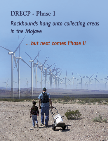
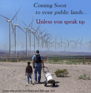
Photo: Lavic Siding, by Kris Rowe, wind turbines by Wiki user Z22, composite art by L. Thoresen.
DRECP, one year later:
implications for rockhounding
by Lisbet Thoresen
January 1, 2016
ROCKHOUNDS AND PROSPECTORS may remember the big push this time last year to get comment letters to the Desert Renewable Energy Conservation Plan (DRECP) before the February 23rd deadline. Access to some favorite collecting areas were at risk of being blocked by an ambitious "re-districting" plan in the works for public lands in California's deserts.
SDMG sent a 48-page comment letter that included results of a SDMG-sponsored Rockhound Survey. There were many other great – really great – comment letters submitted by individuals. The letters provided succinct but specific details about the exceptions that needed to be applied to land use designations. The comments very specifically targeted the areas where access was a concern. It appears that all the comment letters submitted and all the appearances rockhounds made at BLM-sponsored public meetings made a difference.
If you go online, you'll see that the DRECP LUPA responded point-by-point to letters from SDMG and others saying no changes were made to the Final Plan because of our letters. However, indeed there were accommodations made specifically for rockhounding activity and for at-risk areas that our letters identified. Good work! Read the article highlighting some of the rock collecting accommodations now incorporated into the Phase I part of the DRECP »
Comment Period Deadline:
January 25, 2016
Email: cawemopa@blm.gov
By post:
Bureau of Land Management
California Desert District
Attn: WMRNP Plan Amendment
22835 Calle San Juan de Los Lagos
Moreno Valley, CA 92553
(Draft EIS and related resources) for the West Mojave Route Network Project (WMRNP)
Another bite at the apple:
West Mojave (WEMO)
Route Network Project
Comment Period re-opened
deadline is January 25, 2016
December 9, 2015
Way back in March, the BLM released the Draft Amendment to the California Desert Conservation Area (CDCA) Plan and Draft Supplemental Environmental Impact Statement (SEIS). The CDCA and SEIS provide direction and guidance on public lands administered by the BLM in San Bernardino, Inyo, Kern, Riverside and Los Angeles counties. The area under management is 3.1 million acres, which is about one-third of the 9.24 million acres covered by the travel management plan. (A description of the WMRNP Draft Amendment Plans under consideration was originally posted in an SDMG article on March 15, with an update on May 1 and an update on June 4.)
The Comment Period has been re-opened. It was prompted by comments received previously and court-ordered adjustments to specific aspects of the plan (primarily focused on correcting errors in some of the maps).
Tips on writing a good comment letter can be found in the March 15th article posted below.
Timing is everything:
Making your voice heard,
and making your words count
by Lisbet Thoresen
December 8, 2015
Written comments submitted to
the Forest Service should:
- Identify changes that need to be made in the existing plan.
- Further develop the proposed action/s under consideration (the first revision of the revised plan).
- Identify "significant issues."
The "significant issues" provide the rationale to develop alternatives that will be considered in the Environmental Impact Statement (EIS). The EIS is the second major step in the NEPA process.
ROCKHOUNDS NEED TO PARTICIPATE MORE in the forums that guide government decision-making, if they want to continue collecting rocks on public lands. Limits on access to collecting sites located on Federal Forest Lands, BLM-administered Parks and Recreational Areas is a problem confronting rockhounds throughout the United States. "Rocking the Vote" where public lands are concerned is one of those rare circumstances when the sum of the parts is greater than the whole, i.e., the clubs. It is up to the individual members to provide the critical mass to make the kind of difference that clubs cannot.
Yes, it seems like an endless cycle of rallying to yet another call for a nationwide response every time a new Revised Plan for Forests, Parks or Recreational Areas is proposed. It is an endless cycle. And it isn't going to end anytime soon. At least, the process is formulaic, so let's look at one of the most important parts of the formula for Revised Forest Plans, so that we know precisely when action is required and when the window of opportunity closes. The key variable in the formula is to submit written comments during the Scoping Period of a proposed Revised Forest Plan.
How and When to Comment Effectively
Like most things, it matters not only what to say or how to say it, but also when and where to say it. The Scoping Phase is one of several steps in the National Environmental Policy Act (NEPA) process that must be undertaken before projects can be authorized to effect Plan changes for Federal Forest Lands. The Scoping Phase gives the public the opportunity to influence the provisions of alternative plans that will be developed and considered later in the Plan revision process.
"Scoping" is the first phase of the NEPA process required for revising a Forest Plan. The Scoping Phase is the opportunity for the Public to voice concerns about policy changes that could adversely impact public interests, if they are incorporated into the alternative plans that will be drafted. The Scoping Period is the time to comment on the rights and privileges you want to retain and do not want to lose.
Why is it important for rockhounds to comment during the Scoping Phase of a Federal Forest Plan?
After the Scoping Phase concludes and the next phase of the Plan revision process has begun, it will too late to propose modifications to provisions of the alternative plans as drafted. That's right, it will not be possible to change elements of the alternative plans or propose creating additional alternative plans. After the Scoping Period concludes, the available options for public comment will be to choose between the alternative plans as drafted. Therefore, it is critically important for rockhounds to comment during the Scoping Period.
Federal regulations require all Forest projects and activities to be consistent with the Forest Plan. If a proposed project is not consistent with the Plan, the project cannot proceed as proposed unless the Plan is amended to conform with the Plan. For example, new motorized routes cannot be approved unless the Forest Plan describes a need for additional motorized routes or meeting motorized recreation needs. Although the Forest Plan itself has no actionable authority, its provisions guide actions that will be taken, so it is VERY important.
What is a good Scoping comment?
The most effective Scoping comments identify issues that you want the Forest Service to address in the new Forest Plan. You do not necessarily have to suggest solutions to a given problem (that is what the Forest Service is supposed to develop during its analysis).
It is unproductive to complain about what you think does not matter, especially criticizing other special interest groups who have their own concerns about preserving wildlands and habitat. (Remember, the BLM has to balance the interests of many special interest groups.) Stick to making points about what does matter – leave access roads open, ensure that onerous permitting requirements are not implemented (e.g., 25 lb. limit per permit), ensure that claims are not revoked or rendered useless because access will be made impractical (e.g., hike or pack in/out only or only the owner of a claim may use an access road). Remind the BLM that recreational rockhounding is a minimally intrusive activity, and rockhounds have a good track record of being responsible stewards of public lands. Rockhounds carry out what we carry in, we don't litter, and we leave the landscape the way we found it. We like coming back to the same places to enjoy their natural beauty unmarred by careless individuals who came before us.
National Park Service proposes incorporating
thousands of acres in Eagle Mountain and Chuckwalla Valley
into Joshua Tree National Park:
Access and collecting areas for rockhounds at stake
Referring to the NPS Newsletter as a reference, public input is sought on the following questions:
- Among the many factors that the NPS will consider in evaluating the criteria and options for a proposed boundary adjustment are public access and the need for the protection of resources associated with the park's purpose. What information should NPS consider in further investigating these topics? Your knowledge of these lands will help inform the evaluation.
- Of the various options presented in the newsletter, which one(s) do think would be most appropriate? Are there other options that you think the NPS should consider?
- What resources in the area do you think are most important? Why?
- Are there other specific areas of concern that the National Park Service should be aware of?
How to Comment
Mail comment letters to:
Joshua Tree National Park
74485 National Park Drive
Twentynine Palms, CA 92277-3597
OR
Email: jotr_study@nps.gov
MORE THAN 100 miners and multiple land use proponents showed up at the August 5th scoping meeting held in Joshua Tree, where the National Park Service (NPS) presented an overview of a Boundary Study that proposes to bring 32,000 acres of land in the Eagle Mountain area and Chuckwalla Valley into Joshua Tree National Park (JTNP). During the 39-day scoping period, public comment is invited on the study and the land use amendments under consideration. The study outlines three alternative action plans plus one No-Action option. According to Walt Wegner, President of Public Lands for the People, his organization, along with First Class Miners and Minerals and the Mining Advisory Council, took the lead at the meeting, with twice as many supporters in attendance than advocates representing environmental groups. Given the location and time of the meeting, the turn-out was better than expected.
After the meeting Wegner wrote: "It is important to become an active participant in this process…. If you like to really 'get out there' and participate in prospecting, mining, primitive camping or hunting, it won't be happening there once it gets designated National Park land. We realize most of you will never visit this area, but what must be accepted is any public land under threat requires a response from us all."
Ostensibly, the Boundary Study is under consideration at least in part because BLM lacks sufficient resources to administer these areas adequately. However, NPS, which is also strapped for resources, acknowledges that it will have to find the funds to take over management of these areas. Details remain to be developed about how NPS will go about it.
Existing mining claims stand to be revoked under the alternatives under consideration. The No-Action alternative is favored by mining groups. Said Wegner: "Our goal is to have 500 comments sent before the August 21, 2015 deadline."
Any boundary adjustments made under the three alternative action plans will also affect traditional recreational uses such as rock collecting in the Eagle Mountain and Chuckwalla Valley areas. Rockhounds need to lend their voices to the actions plans under review, not only the No-Action alternative. Should one of the alternative action plans gain traction it will be important to articulate specific exceptions to exclusions under the changed land use designation.
Boundary adjustments for Eagle Mountain area under review:
Input from Rockhounds needed to preserve collecting areas and access
How to Comment
Attend one of the public meetings, mail or e-mail your written comments (see contact information below), or submit your comments online via the study website.
Public Scoping Meetings:
Eagle Mountain Boundary Study – Joshua Tree
August 4, 5 and 6, 2015
Time: 6:00–8:00pm
- Tue, Aug 4 – Desert Center
Lake Tamarisk Community Center
26251 Parkview Dr. 92239
- Wed, Aug 5 – Joshua Tree
Joshua Tree Community Center
6171 Sunburst St. 92252
- Thu, Aug 6 – Palm Desert
UCR Palm Desert Center
75080 Frank Sinatra Dr. 92211
The public is welcome to join park staff and planners to learn about and discuss planning.
Comment period closes 8/21/2015
Mail comment letters to:
Joshua Tree National Park
74485 National Park Drive
Twentynine Palms, CA 92277-3597
OR
Email: jotr_study@nps.gov
How to Comment
Attend one of the public meetings, mail or e-mail your written comments (see contact information below), or submit your comments online via the study website.
Public Scoping Meetings:
Eagle Mountain Boundary Study – Joshua Tree
August 4, 5 and 6, 2015
Time: 6:00–8:00pm
- Tue, Aug 4 – Desert Center
Lake Tamarisk Community Center
26251 Parkview Dr. 92239 - Wed, Aug 5 – Joshua Tree
Joshua Tree Community Center
6171 Sunburst St. 92252 - Thu, Aug 6 – Palm Desert
UCR Palm Desert Center
75080 Frank Sinatra Dr. 92211
The public is welcome to join park staff and planners to learn about and discuss planning.
Comment period closes 8/21/2015
Mail comment letters to:
Joshua Tree National Park
74485 National Park Drive
Twentynine Palms, CA 92277-3597
OR
Email: jotr_study@nps.gov
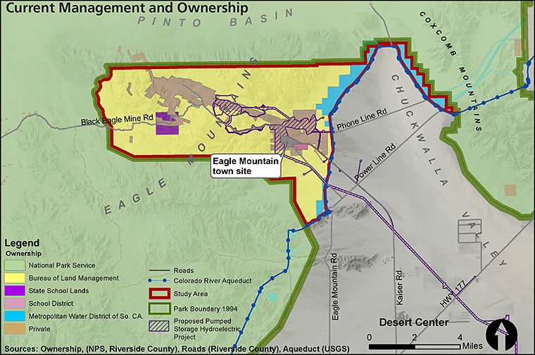
THIRTY-TWO THOUSAND ACRES in the Eagle Mountain area of Riverside County are under review by the National Park Service (NPS) for annexation into Joshua Tree National Park. The study area is bounded by the park to the west, north and south. The Colorado River Aqueduct and Chuckwalla Valley lies to the east. The Public Scoping, Eagle Mountain Boundary Study Newsletter 1 provides maps and detailed information about the study and how the public can participate. Four alternative plans (including a No-action Plan) are under consideration, and collecting and/or access to collecting areas will be impacted under the proposed options.
Rockhounds are encouraged to join The First Class Miners and Public Lands for the People at the August 5th public meeting in Joshua Tree to voice your opposition to changes that will curtail collecting or inhibit access to collecting areas. At this meeting, the mining community needs to be seen and heard like never before. Your attendance is important.
Referring to the Newsletter as a reference, the National Park Service is asking for public input on the following questions:
- Among the many factors that the National Park Service will consider in evaluating the criteria and options for a proposed boundary adjustment are public access and the need for the protection of resources associated with the park's purpose. What information should NPS consider in further investigating these topics? Your knowledge of these lands will help inform the evaluation.
- Of the various options presented in the newsletter, which one(s) do think would be most appropriate? Are there other options that you think the NPS should consider?
- What resources in the area do you think are most important? Why?
- Are there other specific areas of concern that the National Park Service should be aware of?
Pew puts a positive spin on DRECP:
Garbage in, garbage out?
by Lisbet Thoresen
July 27, 2015
High favorability for renewable energy plan's premise,
but poll omits questions about the actual plan
LOST IN TRANSLATION. Concluding its 5-year gestation period in February, and weighing in at a whopping 8,000+ pages, the Desert Renewable Conservation Plan (DRECP) has entered its next phase of development, which aims to create an energy-independent California through development of a renewable energy strategy encompassing 22 million acres of public lands in Southern California deserts. No one disputes the laudability of its intent, which purports to balance a broadly based renewable energy program with conservation concerns for wilderness areas. However, by the close of the comment period on February 23rd, the Draft Plan had drawn more than 12,000 comment letters, many of which were extremely negative – a generally good idea had been poorly developed and badly mangled translating it into functional blueprint that would guide energy development and land use for the next 25 years. No one advocates doing nothing, but careful review of the DRECP raised real concerns that a thing done badly not only may not fix our energy problems, it may introduce a cascade of unintended, costly and irrevocably bad consequences.
The DRECP drew withering criticism from concerned individuals, watchdog groups and even government agencies such as the Environmental Protection Agency (EPA). Environmental journalist Chris Clarke pointed out, "Five of the seven counties included in the plan area have expressed reservations about participating, and both environmental groups and energy companies have slammed the DRECP's mind-numbing complexity and apparent inconsistencies." Many special interest groups contributed comments, including a large number of rockhounds, who participated in a survey sponsored by SDMG in which they expressed their concerns about the potentially negative impact on access to collecting areas. Advocacy groups based in the Mojave Valley were especially effective in raising public awareness and galvanizing public sentiment. Alliance for Desert Preservation (A4DP) and Mojave Communities Conservation Collaborative co-authored a 215-page comment letter, providing surgically targeted comments on detailed aspects of the entire 8,000+ page tome, focusing on defective arguments derived from faulty or incomplete data, inconsistencies peppered throughout the document, and vague language that left key provisions open to later interpretation and decision-making without public accountability. (In January, A4DP had submitted a comment letter exposing the DRECP's potentially fatal flaws and calling out the Plan's inherent vice. It cited, among its several critical arguments, the Plan's explicit scope – administering 22.5 million acres within the defined DRECP area – in fact, may be extended implicitly, at the discretion of the BLM, beyond the Plan's current boundaries.)
Following a deluge of excoriating comment letters on the Desert Renewable Conservation Plan (DRECP), its sponsors drastically revised its planned implementation, announcing in March that the DRECP would be rolled out in phases. It would focus first on about 10 million acres of public lands and delay action on the portion of the Plan covering private land. Since March, few details have been forthcoming about serious overhauling of the document or other indications that remediation is planned in response to public comment. Perhaps, the main strategy may be to enlist support for the DRECP with little or no revision by mounting a public relations campaign. A Pew Poll conducted in June may be the harbinger of precisely such a strategy.
In stark contrast to the relentlessly negative public feedback during the comment period, the U.S. Public Lands Program of the Pew Charitable Trusts published a remarkably upbeat public opinion poll on the DRECP. Among the 807 California voters polled, fewer than one in four had ever heard of the DRECP. But when given a brief description, 74 percent expressed approval. Although Pew enjoys a sterling reputation as an unbiased pollster, the DRECP comment letter from the Pew Charitable Trusts may have presaged the quality of the survey administered in the aftermath of the DRECP's lambasting from so many other quarters, including from state and federal agencies. Pew's eight-page letter was overall very positive on the Draft DRECP, offering only mildly critical input.
In a July 22 article reflecting sentiment in the local community, the Victorville Daily Press voiced concern that the Pew poll pitched softball, even misleading questions. As reported in the article, Betty Munson, who is a member of the Lucerne Valley-Johnson Valley Municipal Advisory Council, echoed Pew's own memorandum (D. Metz, M. Everitt, and Fairbank, Maslin, Maullin, Metz & Associates, 7 July 2015), observing that only about one in four respondents who were polled had heard of the DRECP, but of those who knew of the plan 67 percent supported it. According to Munson, the voters polled had not read the public comments posted on drecp.org website. And according to John Zemanek, spokesman for Alliance for Desert Preservation: "most of the people polled had never even heard of the DRECP. During the telephone interviews, pollsters told respondents that the DRECP 'uses the best available science to identify places most appropriate for developing additional renewable energy over the next 25 years, as well as places where natural areas and wildlife species should be protected.'" Said Zemanek: "In other words, the plan was characterized in the glowing terminology of the plan's own authors. It's a wonder only 74% indicated support." He went on to say: "Pollsters failed to inform those whom they called that the DRECP would site 20,000 megawatts of renewable energy projects on hundreds of thousands of acres of California desert." Interviewed subjects were not told other facts, such as the current status of projects begun recently or online since 2008. They were not told current information about distributed energy generation alternatives (e.g., rooftop solar) or that only utility-scale projects were proposed in the DRECP. They were not told cost estimates or who would bear them to build, maintain or decommission the facilities or the infrastructure (transmission corridors) needed to connect them to the power grid. (In fairness, the DRECP does not spell out any of this, so the pollsters could not be faulted for withholding information no one knows.)
Zemanek voiced the concerns of citizens who are disturbed about the manner in which the Pew survey was administered, saying: "We attended a number of the public-comment meetings after the draft plan was released…The vast majority of people who spoke – people well informed of the proposed plan's actual content – were strongly opposed to major parts, if not all, of the draft. The objections clearly prompted the DRECP agencies to go back to the drawing board. We don't want to see these objections drowned out by a misleading poll." Indeed, rather than cultivating anew a different consensus from an uninformed survey pool, the DRECP sponsors should heed the voluminous and thoughtful input received already from informed individuals and groups. It's time the DRECP's authors roll up their sleeves and overhaul the document, not rebrand it. They could help hasten the process toward a workable solution by inviting to the table advocates from the diverse special interest groups who have reviewed the DRECP and have submitted detailed, constructive letters.
West Mojave Route Network Project (WMRNP) –
Blue Ribbon Coalition letter generator
by Ron Schiller
June 4, 2015
LAST CHANCE TO WEIGH IN!
Deadline for comments is June 4, 2015
Input from Rockhounds is needed TODAY
Tell BLM to keep camping, staging areas
and access roads OPEN
As I'm sure you know, many of us have been working hard to provide meaningful comments to the BLM regarding the West Mojave Management Plan (WEMO) by the June 4th deadline.
There is a way that you can very easily provide comments electronically, and it only takes a few minutes of your time. The Blue Ribbon Coalition (BRC) has set up a very easy-to-use letter generator on its website to help you write your own letter and send it to the BLM via the Internet. The basic letter is already written and you only have to fill in your name, email address and street address. You can add your own words or select from a menu of pre-written optional comments and then click on the send option and you're done!
Although the Blue Ribbon Coalition is primarily an off-road interest, you can input your own personal interests in the letter and tailor it to address your personal concerns. For example, under current regulations you must park or camp within 300 feet of a designated road, but the preferred alternative favored by the BLM limits parking and camping to within 100 feet. Many times a group of rockhounds on an overnight field trip or a group of equestrians camping with horses and trailers need to be a little farther away from the traffic, noise and dust caused by passing vehicles. If this is an issue for you, then you can add it before submitting your comment. Include in your letter how you and your family recreate on our public lands in the desert, and be sure to support the Alternative Plan 3 for the final WEMO plan. Make it look personal because the BLM hates form letters.
The BRC letter generator is online at: www.sharetrails.org/issues/rapid-response-center. Please go to the website to formulate your letter NOW.
West Mojave (WEMO) Route Network Project:
Draft Plan Amendment
by Lisbet Thoresen
May 1, 2015
The clock is running down…
comment period deadline is June 4, 2015
Input from Rockhounds is needed NOW
Tell BLM to keep camping, staging areas
and access roads OPEN
WMRNP/SEIS
On March 6, 2015, the BLM released the Draft Amendment to the California Desert Conservation Area (CDCA) Plan and Draft Supplemental Environmental Impact Statement (SEIS) for the West Mojave Route Network Project (WMRNP). The CDCA and SEIS provide direction and guidance on the management of over three million acres of public lands in San Bernardino, Inyo, Kern, Riverside and Los Angeles counties.
Acronym Soup
ACEC. Area of Critical Environmental Concern
CDCA. California Desert Conservation Area
DRECP. Desert Renewable Energy Conservation Plan
SRMA. Special Recreational Management Area
NLCS. National Landscape Conservation System
PAP. Preferred Action Plan
SEIS. Draft Supplemental Environmental Impact Statement
SRMA. Special Recreational Management Area
RESOURCES
BLM Field Offices within WEMO planning areas
- Barstow – 2601 Barstow Road, 92311
- Ridgecrest – 300 S. Richmond Rd., 93555
- Needles – 1303 S. Hwy 95, 92363
- Palm Springs – 51-500 Highway 74, 92260
FEDERAL REGISTER WEBSITE
(General info on Plan Draft Amendments)
https://federalregister.gov/a/2015-05127
WMRNP/SEIS maps (short urls)
- http://goo.gl/Vu5PzV (all maps except alt plan)
- http://goo.gl/Tb3Yr7 (alt plan map only)
WMRNP/SEIS and related resources (short urls)
- http://goo.gl/4k1HQp
- http://goo.gl/SpGTwp
(PDF of Draft Plan Amendment)
Comment period Deadline: June 4, 2015
- Email: cawemopa@blm.gov
- By post:
Bureau of Land Management
California Desert District
Attn: WMRNP Plan Amendment
22835 Calle San Juan de Los Lagos
Moreno Valley, CA 92553
A proposed land use amendment for 3.1 million acres of BLM-administered lands in five southern California counties is under review now, with barely 30 days remaining for public comment. Three Alternative Action Plans are under consideration. Proposed revisions embodied in these Plans will affect travel management networks and off-highway vehicle (OHV) access and other recreational uses (including rockhounding).
What's the issue for rockhounds? The Preferred Alternative Plan (PAP), which is the likeliest plan to be adopted, limits off-route stopping/parking within the planning area. The current locations of camping and staging areas may be moved and/or consolidated into fewer locations. New designations will be based on trying to balance competing concerns such as environmental values and recreational uses.
Calling all rockhounds (yes, input is still needed). It's up to us to submit comments identifying the specific collecting areas and access roads/trails that should remain open to rockhounding activity. The train has already left the station concerning areas previously designated as "Closed" to motorized access.
There is no use commenting on these "Closed" areas, they are outside the scope of the current review. The areas covered in the WMRNP/SEIS were previously defined as "Limited" to designated routes for motorized access. Only these "Limited" areas are within the scope of review.
Write an effective comment letter –
what helps, what doesn't.
Factual and detailed information voiced in a respectful tone reflects positively on all rockhounds as a community. Coming to the discussion as proactive stakeholders improves the prospect of getting the outcome we want. Just like the DRECP, maps are useful tools to show the BLM precisely which areas and access roads/routes concern rockhounds.
Be specific. Comments such as "Don't close any access roads to collecting areas in the Mojave Desert" are too generalized to be effective.
Target comments on areas designated "Limited." Refer to the WMRNP/SEIS maps that identify these areas. (See links in adjacent Resources box.)
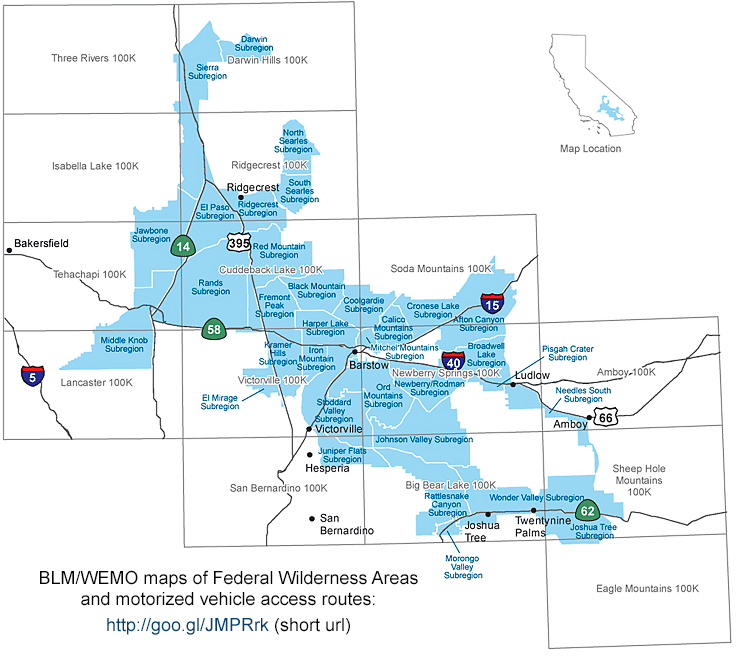
WEMO map of Federal Wilderness Areas and road access.
Stick to facts couched in a positive tone. Diplomatic restraint will bolster an argument, emotional frothiness only detracts and undermines the credibility of a good argument. Critical comments about the values of other stakeholders (e.g., OHV, environmentalists, etc.) are counter-productive.
Which land use designations protect recreational uses over the long term and which may not? Designations intent on protecting critical habitat, environmentally sensitive areas, or scenic and wilderness areas do not have to be at odds with rockhounding or other recreational activities, if BLM incorporates language that specifically stipulates exceptions for rockhounding.
Indeed, the tougher environmental protective designations (e.g., NLCS, ACEC) – qualified by exceptions for rockhounds – may save the desert from future industrialization and preserve it for the enjoyment of the public, whereas Special Recreational Management Areas (SRMAs) and other designations, which are vulnerable to future revision allowed by the DRECP, may not (see Alliance for Desert Preservation's excellent comment letter to the DRECP at: http://goo.gl/czCP4U [short url], see especially pp. 6, 53ff).
For more about this topic, see the March 21 article on the SDMG website at: blm.sdmg.org/#awemo0315
West Mojave (WEMO) Route Network Project: Draft Plan Amendment Released
Camping, staging areas and access roads need Rockhound input
90-day comment period deadline is June 4, 2015
March 21, 2015
WEMO Public Meetings
All meetings are 6:00–9:00pm and include a presentation, open house and opportunity to provide written comments. The BLM will review input received through the public comment period ending June 4, 2015 when making a decision on the final plan. (PDF version of the Draft Plan Amendment.)
- Tue, Mar 31 · Ridgecrest
Kerr-McGee Center, Pinnacles Room
100 W California Ave. - Thu, Apr 2 · Victorville
Hilton Garden Inn
12603 Mariposa Rd. - Thu, Apr 7 · Lone Pine
Lone Pine Community Center, Stratham Hall
138 Jackson St. - Wed, Apr 15 · Yucca
Yucca Valley Community Center Complex
Yucca Room
57090 Twentynine Palms Highway
Comment period Deadline: June 4, 2015
Email: cawemopa@blm.gov
By post:
Bureau of Land Management
California Desert District
Attn: WMRNP Plan Amendment
22835 Calle San Juan de Los Lagos
Moreno Valley, CA 92553
On March 6, 2015, the BLM released the Draft Amendment to the California Desert Conservation Area (CDCA) Plan and Draft Supplemental Environmental Impact Statement (SEIS) (Draft EIS and related resources) for the West Mojave Route Network Project (WMRNP). The CDCA and SEIS provide direction and guidance on the management of over three million acres of public lands in San Bernardino, Inyo, Kern, Riverside and Los Angeles counties.
According to the BLM, the CDCA plan amendment proposes plan revisions related to travel management networks and off-highway vehicle access, livestock grazing and recreation (that's us, folks) within the West Mojave (WEMO) planning area managed by the BLM's Field Offices in Barstow, Ridgecrest, Needles and Palm Springs. General information abou the Draft Amendment to the Plans can be found at https://federalregister.gov/a/2015-05127.
Scope of the Draft Amendment Plans. The lands covered in the WMRNP are areas previously defined as "Limited" to designated routes for motorized access. Areas defined as "Closed" to motorized access are outside the scope of the planning effort. According to the Federal Register website, the current DRAFT Plans have been revised from the previous iteration:
"In response to public input, access considerations focused on maintaining a viable transportation network, diverse recreational opportunities, providing access for specific users, (including rock-hounders, motorcyclists, scientific and educational activities, and non-motorized users), dealing with conflicts between users, and maintaining commercial access needs."
Three Alternative Action Plans are under consideration. The Preferred Alernative Plan includes a "regional mitigation strategy" for limiting off-route stopping/parking within the boundaries of the planning area with the aim of minimizing adverse impacts to undisturbed habitat or environmentally sensitive areas. The locations of camping and staging areas will be designated based on consideration of competing concerns such as environmental values and recreational uses.
Calling all rockhounds. It's up to us to submit comments identifying the specific collecting areas and access roads/trails that should remain open to rockhounding activity.
Tips on writing a good comment letter. Comments such as "Don't close any access roads to collecting areas in the Mojave Desert" are too generalized to be effective. Critical comments about the values of other stakeholders (e.g., OHV, environmentalists, etc.) are counter-productive. It's more useful to point out how rockhounding ethics are concerned with preserving the natural character of wilderness areas with minimal intrusion on the environment and habitat. Rockhounds are concerned with continuing to have access to collecting areas that we've enjoyed for decades. Factual and detailed information voiced in a respectful tone reflects positively on all rockhounds as a community. Our concerns stand the best chance of fair hearing if we come to the discussion as proactive stakeholders. Just like the DRECP, maps are useful tools to show the BLM precisely which areas and access roads/routes concern rockhounds. An interactive map tool and WEMO supplemental maps are available on the BLM website to help you identify areas relevant to your comments. See also BLM/WEMO website detailed maps of Federal Wilderness areas and motorized vehicle access routes (map of scope areas shown below).
Four public meetings are scheduled through April, 2015 (see box at right). Rockhounds can make a strong impression by attending the meetings and participating in constructive dialogue.
Who's fighting the good fight?
– a model of effectiveness
– useful information
Alliance for Desert Preservation (A4DP)
Effective comment letters to DRECP. Concerned with Lucerne Valley, primarily, but everyone who cares about the California desert stands to win if A4DP prevails.
Tubb Canyon Desert Conservancy (TCDC)
Sponsored a petition to ask DRECP to consider a distributed energy alternative plan to the DRECP's five utility-scale plans that threaten to industrialize the California desert. Thank you, if you were one of the 12,000 signatories to the petition.
mojavedesertblog.com
Thoughtful wildlife and conservation-focused blogger. Great information. (Helped SDMG write our proposed revisions to land use designations to protect rock-collecting areas.)
Mojave Communities Conservation Collaborative
Co-wrote terrifically effective comment letter to DRECP (with Alliance for Desert Preservation). Supportive of rockhounds.
Basin and Range Watch
SDMG signed on to BRW's letter to DRECP for its proposed alternative energy plan. Daily factual reporting of what is going on in the California desert.
Chris Clarke
Natural history writer and environmental journalist based in Joshua Tree. Investigative reporting on the DRECP.
The DRECP comment period
ended February 23, 2015
What's next?
February 28, 2015
by Lisbet Thoresen
SDMG's Desert Renewable Energy Conservation Plan (DRECP) campaign. Many individuals and organizations worked tirelessly to review the voluminous DRECP document published on September 26, 2014, so they could prepare cogent comment letters by the February 23, 2015 deadline. Shirley Leeson took a leading role to rally the rockhounds, from whom the BLM had heard very little during the comment period. She prepared a rockhound survey, which SDMG sponsored and publicized with a grassroots campaign. SDMG's intention was to include the survey results in our comment letter.
Getting rockhounds on record. To our knowledge, no study has ever been performed to characterize amateur rock collecting as a recreational activity on public lands in California. We felt that the changes we proposed to the DRECP would be bolstered by the survey information. In 11 weeks, 177 individual respondents took the survey. SDMG's letter included specific requests that BLM apply land use designations to protect 19 "at risk" collecting areas and ensure vehicular access to them through adjacent lands. On February 23rd, SDMG's comment letter on the DRECP was submitted to the DRECP, and also to the commissioner and directors of the relevant agencies – California Energy Commission (CEC), Bureau of Land Management (BLM), California Dept of Fish and Wildlife, US Fish and Wildlife Service. Copies were also sent to California state Senators Dianne Feinstein and Barbara Boxer, and California 50th District Representative Duncan Hunter. Based on the number and quality of defects called out in comment letters docketed during the comment period, we hope that the public can look forward to seeing significant revisions made to the plan.
Other forces are now in play. On February 9, Senator Dianne Feinstein introduced the California Desert Conservation and Recreation Act of 2015. This bill, which is co-sponsored by Senator Barbara Boxer, is an updating of the California Desert Protection Act of 1994 and purports to "protect additional land and help manage California's desert resources by carefully balancing conservation, recreation and renewable energy development." It seems clear that the proposed bill complicates the glide path for the DRECP. We need the concerns of the rockhound community to be incorporated into the Feinstein-Boxer bill. Certainly, we'll be weighing in over the weeks and months ahead. The DRECP is shaping up to be a monumental brawl over the biggest land use amendment proposal in California in the past 30 years. We'll need to galvanize a whole lot more constructive effort from our community stakeholders. According to Shirley Leeson, there are over 52,000 organized (club-affiliated) rockhounds in the United States, with 10,000 rockhound members of gem-mineral societies in California and Nevada. This time around, a few people cannot do everything for everyone else – the strength of numbers is needed. Read the whole article »
Storm clouds gather over California's deserts*
January 26, 2015
by Lisbet Thoresen
Natural habitat, ecosystems, and scenic and wilderness areas, as well as geologically distinctive or historically significant areas in the California desert will be altered dramatically, perhaps irrevocably, if the Recommended Alternative Plan of the Desert Renewable Energy Conservation Plan (DRECP) is adopted as drafted currently.
Southern California desert communities can look forward to the unspoiled vistas and natural environment they value being blighted by the construction of power transmission corridors through public lands and utility-scale projects on adjacent private lands. Areas previously accessible for recreational uses, including sites that have been popular with amateur rockhounds for many decades, may be closed or become inaccessible due to trail and road closures on adjacent lands. At the least, recreational users can look forward to restricted access and an uncertain future in which development trumps other considerations on BLM-administered lands. Read the whole article »
* This article is a revised version of an article that originally appeared here on January 8, 2015.
Download a print-friendly version of the article.
What is the Desert Renewable Energy Conservation Plan?
(DRECP)
Land usage encompassing 22.5 million acres of California's deserts will be administered according to DRECP guidelines for the next 25 years. The plan makes a mosaic of the desert, with Development Focus Areas (DFAs) designated for private industry to build utility-scale energy projects adjacent to public lands or on 177,000 acres of BLM-administered public lands. DRECP's implementation will pave the way for large industrial developments to be connected to the power grid via power transmission corridors running through fragile ecosystems and pristine natural landscapes on public lands.
BLM needs to know your concerns about preserving the desert environment. BLM needs to know about the specific areas for which recreational uses or conservation concerns are important to you.
The comment period for the DRECP, which closes on February 23rd, provides opportunity for the public to influence provisions that determine the destiny of our public lands.
Six things you can do:
1. Comment directly to the DRECP at:
http://www.drecp.org/about/contact.html#comments
(Tips for rockhounds on writing an effective letter »)
2. Take SDMG's Survey
San Diego Mineral & Gem Society online Survey
Final Deadline: Feb 15, 2015
3.–5. Sign on to letters and petitions
that will improve the DRECP
and the public comment process
Sign the Garmon Petition:
We don't have to sacrifice California's deserts
for renewable energy!
Sign the Basin and Range Watch Letter
proposing a new alternative distributed energy plan
6. Hit the grapevine and help get the word out
Download, cross-post – print
and tweet:
#drecp
#ghostsofthedesert
@SaveTheDesert
@Desertpreserve #a4dp
@noonwindmills #noonwindmills
#solar #GoSolar #SupportSolar
#windfarms
Let's get that rock to roll downhill and get the word out: please retweet or help the topic trend on twitter by using the hashtags: #ghostsofthedesert and #DRECP
DRECP rocks #ghostsofthedesert w 25yr plan denying access to rec use of Calif deserts. Weigh in on survey at http://t.co/w1n9QZshPD
— Lisbet Thoresen (@ThoresenL) December 3, 2014
SDMG DRECP Survey submitted at
Dec 6th BLM meeting on DRECP
December 15, 2014
A small group of recreational rockhound advocates, including American Lands Access Association (ALAA) President Shirley Leeson, attended the BLM Desert Advisory Council (DAC) meeting held in Palm Springs on December 6th. The meeting agenda focused on the Draft DRECP (Desert Renewable Environmental Conservation Plan), which after five years, will close to public comment on February 23rd, 2015. Five alternative action plans (plus one "no action" plan) are under consideration. All five plans propose development of renewable energy projects on public lands and will curtail or severely restrict recreational use of many popular rock and fossil collecting sites. The Final Plan will be in effect for the next 25 years – through 2040.
To date, input on the Draft DRECP from mineral club members, amateur rockhounds and the public has been limited, so Ms. Leeson prepared a survey to give rockhounds a platform to weigh in on the Draft DRECP before it is codified, carved in stone, and rockhounds are shut out from our favorite haunts in Southern California's deserts for a generation.
Shirley presented the survey responses tallied between December 2nd and 5th at the BLM-DAC meeting. In just two and a half days, more than 100 respondents took the survey, many relating poignant personal experiences and writing about the significance of preserving public lands for posterity. Read Shirley's report on the BLM-DAC meeting below.
Shirley Leeson and San Diego Mineral & Gem Society thank everyone who rallied on short notice and participated in the survey. It's a great start. To be sure, if we are to avoid becoming #ghostsofthedesert, a lot more input will be needed.
- Spread the word far and wide and get trending on twitter with hashtags #ghostsofthedesert and #DRECP
- Take SDMG's DRECP Survey here
- Post/like/friend desert advocates on Facebook
- Check out what others are doing to preserve California's deserts
Rockhounds – Ghosts of the Desert
Status update: Dec 6th BLM meeting on DRECP
December 12, 2014
By Shirley Leeson, ALAA President
As we bring to a close 2014, I look back on all the things that have happened this year… and it's overwhelming. But the most pressing issue right now is the DRECP (Desert Renewable Energy Conservation Plan) – five years in the making by those hell bent on closing to recreational use what little is left of the Southern California Desert, which amounts to less than 10 percent of the State's public land. All the special interests have carved out various areas that have taken away millions of acres of land once designated as "multiple use." It is land we all could share and enjoy. Now, many places have fences and locked gates and worse still, giant areas are covered with solar panels – and there are more to come, along with wind turbines. Jerry Brown, Governor of California, has made it his priority to get all his renewable energy plants built in the desert and use public land to do it.
All the state and federal governments are working in lock-step to achieve the Governor's objective. Rockhounds are in the middle of this and at the bottom of the priority list. We were not asked to sit at the table during the last five years and give our input. Their goal is "planning for renewable energy development while protecting habitat in the California Desert." Nowhere does it say, any of this plan favors recreation or multiple use by people.
I spoke to the BLM's Desert Advisory Council on Saturday, December 6th. I called rockhounds "The Ghosts of the Desert." The endangered Species. Rockhounds are the forgotten people of the desert. There are thousands of us, many of whom have been calling the desert our second home since the 1960s. We leave little behind to indicate that we've been there. We carry out others' trash, as well as our own. Unlike the protected desert tortoise and other endangered species which have had thousands of acres set aside, the rockhound may be entirely shut out of our beloved desert.
At the BLM meeeting, I asked for help in setting aside some of our sacred places. Help with ensuring rockhound areas are included in the DRECP. I reminded some of the meeting participants that there was an unanticipated economic impact. Rockhounds spend money in the small towns spread throughout the Southern California Desert – at service stations, motels/hotels, grocery and convenience stores, specialty shops and restaurants. If we are locked out of our traditional collecting sites, we won't be coming through nearby towns any longer. One of the attendees at the meeting is an "At Large Public" representative on the DAC. He is from Barstow, a stopping off area for rockhounds, and he is well aware of the economics of the situation. He received a copy of the SDMG Rockhound Survey, as did Katrina Symons of the Barstow BLM Office and also Kim Campbell Erb. The survey measured about an inch and a half thick and was seen by all the DAC members and meeting attendees.
I got entered into the record a number of specific areas of concern to rockhounds. First, our Memo of Understanding regarding the Wiley Wells, Hauser Bed area. They are checking on its status, but we believe that it has been put into the Plan. Second, I cited the following areas: Lavic Siding, Broadwell Dry Lake and Ludlow area, all of which are in the vicinity of Hector and Ludlow, along Route 40; Cady Mountains; Gem Hill; Lonely Butte (Brown Butte, off Highway 58); North Edwards/Aerial Acres and roadside collecting along Clay Mine Road, off Route 58; Mule Canyon, near Calico Ghost Town off I-15; Marble Mountains near Cadiz, off the National Trails Highway (Old Route 66); and Kramer Junction. I know there are more areas I should have proposed such as Afton Canyon and others, but this is a start.
Were there any rockhounds at the meeting supporting the case to keep collecting sites accessible at this critical time? NO, THERE WERE NOT. Dee Holland, Jay Erb (Kim Campbell Erb currently sits on the DAC) and I carried the burden alone. We hope to see more of you at the next meeting.
Watch for developments that are coming in other states. A push by Congress this month – December 2014 – is going to see bills attached to many of the important funding items on the legislative agenda. We have already seen the closing of a number of areas in Montana (see the article below on the Lolo National Forest collecting site) and Colorado. Please watch closely, and let us know (info@amlands.org) about anything you read or see about public lands in your state. And please rejoin ALAA. Dues are due now.
Rockhounds – Ghosts of the Desert
Slated to lose access to collecting sites for the next 25 years
December 1, 2014
Make your voice heard by taking the Survey for DRECP
First Deadline: December 5, 2014 (in time for Dec 6 BLM mtg)
The Draft Desert Renewable Energy Conservation Plan (DRECP) Environmental Impact Report/Study (EIR/EIS) proposes changes in land development for geothermal, solar, wind energy projects and imposes severe limits on recreational uses of Southern California's deserts. The final Plan will be in effect for the next 25 years (see details and background below). Currently, the Draft DRECP (EIR/EIS) contains five alternative action plans, all of which propose to limit or curtail access to rock- and fossil-collecting sites on public lands that have long been popular with amateur rockhounds and fossil collectors. We are confronting closures to many of our most popular collecting sites in California, including Wiley Wells area, Gem Hill, Lone Butte, the Cady Mountains and Lavic Siding.
To date, members of gem-mineral clubs and rockhounds have contributed little input to the Draft DRECP (EIR/EIS), so not surprisingly, the action plans do not reflect the concerns of our constituencies. The comment period on the Plan has been extended to February 23, 2015. This is our last chance to have a say about access and recreational uses of our public lands through 2040.
SDMG wants your input on the important public policy matters set forth in the Draft DRECP (EIR/EIS). If you are an amateur rockhound, a member of a gem-mineral club, or a concerned citizen who wants to continue having access to and recreational use of public lands that you've enjoyed for decades, please take the time to fill out the survey form.
ALAA President Shirley Leeson will compile the survey data collected through Friday (2:00pm), December 5th, and present the results at the December 6th BLM DAC meeting in Palm Springs. All the results collected and compiled through February 15th, 2015 will be submitted to the BLM-DRECP prior to the close of the comment period on February 23.*
Note: the final deadline for the survey has been extended from December 15, 2014.
2014 – a tough year for rockhounds
By Lisbet Thoresen
November 21, 2014
DRAFT DRECP EIR/EIS
Comment period extended through Feb 23, 2015
The comment period has been extended on the Draft Desert Renewable Energy Conservation Plan (DRECP) Environmental Impact Report/Study (EIR/EIS), which will guide land use/development in California's deserts through 2040.
Originally scheduled to close on January 9, 2015, the new close date of the comment period is February 23, 2015.
Voice your opinion about the alternative action plans and administrative changes under consideration – they will directly affect access or closure to rockhounding sites for a long time to come. How to stay informed or comment:
- DRECP e-mail, s-mail (commenting guidelines)
- DRECP Listserv sign-up
- DRECP Gateway interactive tools & maps
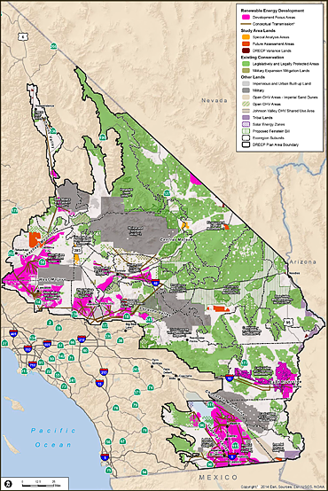
Preferred alternative – Plan-wide development focus area.
View large-size map
Limiting or curtailing access to publics lands and rock collecting areas has been an ongoing longterm trend. In April, rockhounds saw the closure of the Lolo Creek Crystal Digging Area in LoLo National Forest (west central Montana) (see Shirley Leeson's report on Lolo on this page). More recently, on October 10, rock collecting sites located in the Angeles National Forest and San Bernardino National Forest were put off limits to amateur rockhounds. In the December issue of the CFMS newsletter, John Martin reported on the new prohibition, which resulted from an Executive Order designating these federal lands as a national monument.
Earlier in 2014, on June 12, California Representative Judy Chu introduced HR 4858: San Gabriel National Recreation Area Act in the US House of Representatives. The bill proposed changes for administrative oversight of more than 600,000 acres of federal lands. The bill included language that recognized amateur rock collecting as a recreational activity. The Executive Order President Obama signed last month placed more than half of this area – 342,177 acres – under the protection of existing laws concerning national monuments. These laws do not provide provisions similar to those in HR4858, which would have exempted amateur rockhounding activity, so such activity is now effectively forbidden in the newly created San Gabriel Mountains National Monument.
Other collecting sites on public lands, specifically in California's deserts, are impacted by the Desert Renewable Energy Conservation Plan (DRECP), which covers more than 22 million acres, including BLM-administered lands, in Imperial, Inyo, Kern, Los Angeles, Riverside, San Bernardino and San Diego counties. In addition to the development of alternative renewable energy plans (e.g., solar, wind turbine, geothermal), other land use considerations such biological habitat and recreation (e.g., rockhounding) fall within the scope of the DRECP. Administration of some areas currently under BLM oversight may be reassigned to other agencies.
Since March 2009, more than 40 publicly noticed meetings have been held to invite discussion and comments on alternative plans being drafted for land use/development through 2040. Five alternative action plans have been drafted, in addition to one no-action plan. They reflect the input of different stakeholder constituencies (read about the background of this project below; view the video overview and introduction of the DRECP).
The public Draft DRECP – five years in the making – reached an important milestone with its publication on September 26, 2014. It is subject to comment by the public and interested parties through February 23, 2015 – another critical milestone. The most recent public meeting was held on November 19th in Joshua Tree. The small window of time through February 23 provides the last opportunity for interested parties to provide comments that may influence the final DRECP. A variety of stakeholders representing the interests of energy companies, environmental advocacy groups and others have been active participants in the development of the DRECP. If we don't take the time or make the effort to contribute constructive comments to the DRECP, more collecting sites may be made inaccessible to amateur rockhounds, and land use policy will be carved in stone with or without our input for the next 25 years.
Lolo National Forest collecting site – Update
By Shirley Leeson
ALAA President – Rockhound Activist
October 19, 2014
If you or your club had thoughts of a field trip, or if this was on your personal 'bucket list' here is a warning about LOLO NATIONAL FOREST, close to Lolo Hot Springs, on the border of western Montana. The collecting site is CLOSED. The closure will remain in effect until rescinded.
I bring this important information to you because the area is being patrolled by the Forest Service Patrol Unit and the local Sheriff's Department. There are penalties and fines.
This area has been a favorite collecting site for quartz crystals going back many years before the Forest Service had jurisdiction. This is one of those 'land transfer' deals.
Unfortunately, rockhounds have not lived up to the AFMS Code of Ethics and the place looks like a WWII war zone. Let me be frank here, many of them were commercial entrepreneurs who were 'out for a buck,' but we're all painted with the same dirty brush.
In speaking recently with the Forest Service Office that oversees the area, we were informed that the closing was because of concern for the public safety – not animals, but humans. It seems the soil is granitic in nature with only a little topsoil, and when the overburden is removed the topsoil is either washed away or blown away, leaving the granitic material. This is susceptible to cave-ins or undercutting.
We have begun preliminary work with the Forest Service office out of Missoula and will keep you informed as to any progress on the re-opening of this area. In the meantime, stay out or face the consequences.
ALAA in Quartzsite 2015
— Shirley Leeson
THINGS TO DO IN QUARTZSITE
IN JANUARY 2015
- Thu, Jan 22 · Ye Old Timer Auction
7:00pm – Senior Center
Moon Mountain Road - Fri, Jan 23 · ALAA Meeting
7:00pm – Quartzsite Alliance Church
720 Desert View
Speaker: BLM Field Mgr John MacDonald
re: La Posa TMP - Sat, Jan 24 · SCRIBE for Editors
9:00am – Senior Center
Moon Mountain Road
Speaker: CFMS President Tom Burchard - Sun, Jan 25 · ALAA Clean-Up
8:00-10:00am – I-10 at I-10 at Tom Wells Road, west of Quartzsite
The ALAA meeting is important because snow birds will have restrictions on the roads they travel in the desert surrounding Quartzsite. BLM Yuma Field Manager John MacDonald will make a presentation on the status of the La Posa Travel Management Plan (TMP). He will address concerns relevant to rockhounds, and the public will have the opportunity to respond to map updates at the January meeting.
See the schedule at right for the ALAA meeting time and place, along with other activities planned in and around Quartzsite during the week before the Tucson Show.
ALAA will be sponsoring its 3rd Annual Clean-Up of a BLM site near Quartzsite on Sunday, January 25. For some perspective on what the clean-up effort accomplishes, in the campaign's first year, BLM estimated that two tons of trash were collected in two hours. Last year a little more than one ton was collected at the same site in two hours. This year ALAA is targeting a new site west of town. It's only two hours, but in that short period of time we make a very big difference, and rockhounds receive good marks from BLM for their efforts.
Online resources concerning compliance
with Bureau of Land Management (BLM) rules
when rockhounding
BLM home website: www.blm.gov/wo/st/en.html
Introduction. BLM definition of Wilderness Areas.
Introduction. BLM definition of Wilderness Study Areas.
Many rockhounding sites in California are located in areas designated by BLM as the California Desert District. Links to maps, rules, governance and permit requirements are found at this url.
BLM FAQs. More useful information for rockhounds is found at BLM Frequently Asked Questions, including specific information about where off-rode vehicle may be driven, rockhounding and prospecting, camping on BLM lands and how to file a mining claim.
Active Mining Claims. Visit BLM Land & Mineral Legacy Rehost 2000 System – LR2000 and the home page for BLM Geocommunicator, which lists map resources for public lands, including the BLM Interactive Map of the US and the BLM Interactive map of the Wilderness Areas of California.
BLM Campgrounds and fees in California.
How to be a responsible visitor on public lands and leaving no trace of your visit.
Palm Springs – South Coast Field Office.
ROCKHOUNDS GIVE SPECIAL MEANING TO ROCK MY WORLD
WHAT'S GOING ON NOW – California Public Lands
West Mojave Route Network Project,
Desert Advisory Council (DAC)
and Desert Renewable Energy Conservation Plan (DRECP)
ACCESS DENIED
(source: http://amlands.org/6652/67112.html)
- Tick Canyon – Howlite
- Stone Canyon – Jasper
- Horse Canyon – Agate
- Morgan Hill Poppy – Jasper
- Last Chance Canyon – Petrified Wood
- Clear Creek Management Area – Serpentine Rock (California State Rock)
- Cady Mountains – Strawberry Onyx
- Death Valley Natl Park – Pink Thulite
- Death Valley Natl Park – Indian Paint Rock
- Death Valley Natl Park – Pink Thulite
- Death Valley Natl Park – Owls Head Sagenite
USEFUL INFORMATION
BLM FAQs
On May 5, 2014, the American Lands Access Association posted an urgent notice on its website concerning the West Mojave Travel Management Plan and its impact on rockhounds, reporting that "The BLM is now requesting that all Gem and Mineral Clubs contact them prior to scheduling field trips to allow them to assess whether or not a Special Recreation Permit is required." More details may be found at: http://amlands.org/6652/67112.html
Background. The BLM's Desert Advisory Council (DAC) was tasked with the responsibility of collecting information and revising the West Mojave Route Project (WEMO RNP), which is a plan concerning administration of many areas (Travel Management Areas) important to rockhounds. The objective of the Project is to revise access to routes and various natural resources, as well as revise their management based on the Council's findings and recommendations. Implementation of recommendations will affect access to and use of rock collecting areas, including old routes that had been closed previously. The WEMO RNP Report of Findings and Recommendations was published on May 24, 2013. Implementation of changes are pending.
Desert Renewable Energy Conservation Plan (DRECP). On April 12, 2011, California Governor Jerry Brown signed into law Senate Bill No. 2X (Joe Simitian, 2011-2012 1st Ex. Sess.), which increases California's renewable energy portfolio standard to 33 percent of all retail electricity sales by 2020. Together with Executive Order #S-14-08, the Senate Bill mandates the development of the DRECP, which is described as "a major component of California's renewable energy planning efforts." The DRECP is a large program being coordinated jointly by the BLM and the State of California in order to identify public lands that are preferred for alternative energy projects and land to be used as mitigation of biologically sensitive areas which will be adversely affected by the implementation of proposed projects. The public notice describes the topic/presentation as follows:
"The Nature Conservancy will provide an overview of their West Mojave Assessment. The DRECP will be a Natural Community Conservation Plan, which will help provide effective protection and conservation of desert ecosystems while allowing for the appropriate development of renewable energy projects. It will provide long-term endangered species permit assurances to renewable energy developers and a process for conservation funding to implement the DRECP. The DRECP will also serve as the basis for one or more Habitat Conservation Plans under the Federal Endangered Species Act. The Stakeholder Committee was established to provide a forum for public participation and input into the DRECP."
Thousands of acres of public lands will be taken away to build wind, solar and geothermal projects. BLM needs to know what areas are important to us in order to preserve them, so that they might avoid building on these areas or excluding us from having access to them. BLM is currently in the scoping period. The size and scope of this project is enormous, but we must address it and respond, if we care about our collecting areas! The DRECP website provides more information on this project: www.drecp.org. Concerned people are encouraged to attend meetings, review documents and write comment letters. Check the DRECP website often for updates. Public notices about forthcoming public hearings, meetings and critical deadlines frequently are posted just days ahead of the date/deadline.
A CHAIN ACROSS THE ROAD AND A KEEP OUT SIGN POSTED –
IS IT LEGAL?
NATIONAL ENVIRONMENTAL POLICY ACT (NEPA)
By Shirley Leeson, ALAA VP – Rockhound Activist
Have you read in the local paper or seen on the TV News feature stories about lawsuits against the US Forestry Service (USFS) and Bureau of Land Management (BLM)? Big words, lots of initials and you have no clue what they are talking about. Would you like to know more but don't know where to turn for this information? I have consulted a group of longtime advocates for access to public lands, and they have shared with me some useful information with the caveat I share it with you.
SOME GOVERNMENT ACRONYMS:
- NEPA – National Environmental POLICY Act
- CEQ – Council on Environmental Quality
- EIS – Environmental Impact Statement
- EA – Environmental Assessment
Signed into law on January 1, 1970, NEPA does not tell us to "protect" the environment. What NEPA does is tell us that we must understand the impacts and effects of the choices we make. In order to understand those choices, an agency has to perform a study. It is supposed to be a scientific study supported by facts, data and logical analysis. The decision that the agency (the USFS or BLM) makes MUST be based on the facts and conclusions derived from the analysis produced for a given study.
NEPA simply tells us to look at what the environmental costs are and make an informed decision. The core of NEPA is to weigh the human benefits of a proposed project against the environmental costs or impact. NEPA does not say that the environment is more important than humans.
Congress's law describing what should be accomplished was broad in scope, but it articulated few details on how to implement it, so the Council for Environmental Quality, known as CEQ, was created. It is a permanent council based in Washington D.C. and is responsible for crafting the details about how to implement NEPA. CEQ is part of the Executive branch of government and therefore is appointed by the President.
Since 1970, the CEQ has created and refined the system, telling agencies how they have to study issues and how to make decisions in order to balance goals. The members of the CEQ are scientists, so not surprisingly, they wanted to see scientific standards applied in the studies. CEQ created three levels of study. EVERY project that has "on the ground" costs must be undertaken under the constraints associated with one of three categories:
- Environmental Impact Statement (EIS) – the biggest, most complex and thorough study; requires full public participation.
- Environmental Assessment (EA) – less complex and thorough than the EIS; can have less public participation.
- Categorical Exclusion (Cat Ex, or "C.E.") – no formal study required (it can be a one page sheet to document an action that was done); no public notice of participation required at all.
When the Forest Service or BLM is planning a project, it has to decide if the analysis will be done as an EIS, EA or Categorical Exclusion. Every project MUST be classified in one of these categories.
The Forest Service, for example, uses Cat Ex for mundane tasks such as putting up signs, toilets, installing a culvert, fixing a fence, grading and maintaining roads. It's called Cat Ex, because these projects are excluded from the requirements associated with an EIS or EA.
Is your head exploding about now from all this? Don't be discouraged. You will eventually find all this information seeps in to your brain and pretty soon you remember all this without even having to go to your notes.
ADDITIONAL ACRONYMS:
- TMR – Travel Management Rule
- MVUM – Motor Vehicle Use Map
CALIFORNIA FORESTS:
- Angeles National Forest
- Cleveland National Forest
- Eldorado National Forest
- Inyo National Forest
- Klamath National Forest
- Lake Tahoe Basin Management Area
- Lassen National Forest
- Los Padres National Forest
- Mendocino National Forest
- Modoc National Forest
- Plumas National Forest
- San Bernardino National Forest
- Sequoia National Forest
- Shasta-Trinity National Forest
- Sierra National Forest
- Six Rivers National Forest
- Stanislaus National Forest
- Tahoe National Forest
For states other than California, search the phrase "Forestry Travel Management Plan Update" on the web.
For those of you with NATIONAL FORESTS in your state, see the additional information below. Lately, it's topical in the news.
The TMR tells each Forest in the system to make a decision for motorized use, and show it on a map called MVUM. It shows where vehicles are allowed by vehicle type and seasonal closures, if applicable. The TMR does not apply to snowmobiles. The routes (trails and roads) get one of three designations:
- Motorcycle only (single track).
- ATV and Motorcycle (under 50 inches wide), but no full-sized vehicles.
- All vehicles (motorcycles, ATVs and 4WD).
The MVUM is determined by a planning process done under NEPA (see above). That planning process is an Environmental Impact Statement (EIS) and is done for the whole forest, or it can be the smaller Environmental Assessment (EA), which is generally used for a smaller area or smaller project. Ranger District level decisions are usually done under EA.
The TMR decisions also determine whether and where people are allowed to go off a designated route to retrieve big game (elk, deer, and bear) and where people are allowed to 'disperse camp.' Those decisions are not shown on the MVUM.
Dispersed camping means camping out of your vehicle. In the past, the common policy was a 300-foot corridor on either side of all forest roads. One may drive into the forest, find a nice spot by the side of the road and set up camp. These corridors are now being challenged. Watch for further developments.
Special Thanks to the WOMEN'S ACCESS COALITION (WAC), which has provided us with this information. WAC is a longtime advocate for access to public lands, and a group that represents decades of experience in dealing with the USFS and BLM.